
North Carolina winter storm to bring ice, snow and freezing rain statewide this weekend as officials urge early preparation.
North Carolina is bracing for a winter storm event this weekend as atmospheric conditions align to bring snow, sleet, freezing rain and dangerously cold temperatures across the state starting Saturday and lingering into early next week.
Governor Josh Stein has declared a State of Emergency ahead of the system, activating the State Emergency Response Team and urging North Carolinians to stock up on supplies and prepare for dangerous conditions.
“This weekend’s winter storm is likely to impact most of North Carolina, so please make a plan now to keep yourself and your loved ones safe,” Stein said during an afternoon briefing.
Storm Timeline — It’s Coming This Saturday Through Monday
Meteorologists are tracking the storm to begin Saturday afternoon in Western parts of the state — with conditions rapidly worsening across the Piedmont and into Eastern North Carolina by Saturday evening and Sunday. The system is expected to linger into Monday, with dangerously cold temperatures sticking around even after precipitation ends.
What Each Region Can Expect
Western North Carolina (Mountains)
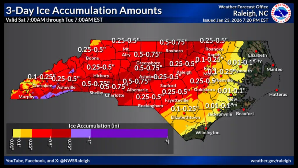
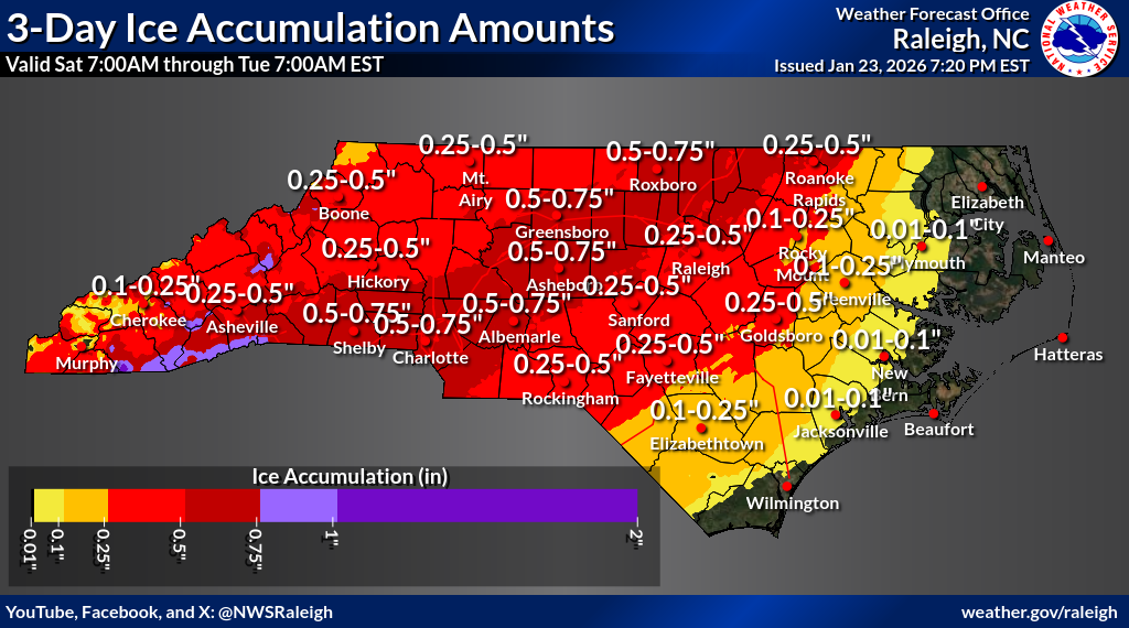
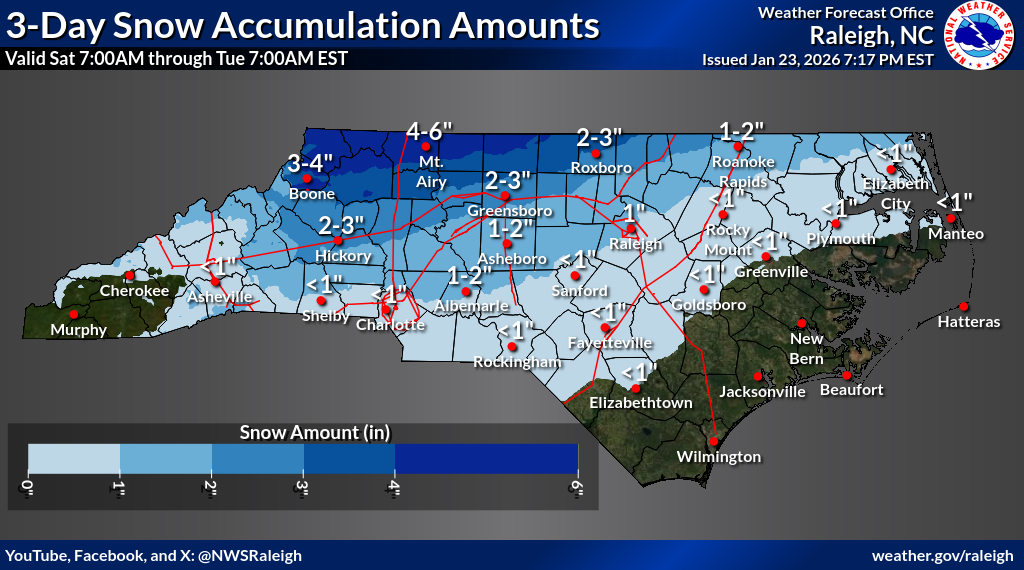
Ice Storm Warnings are in effect for much of the mountainous region, including Asheville and nearby communities. Multiple weather models show significant ice accumulation on trees and power lines, which could lead to outages lasting into early next week. Snow is also possible in higher elevations, though ice is expected to be the dominant hazard in this area.
Piedmont & Triad (Greensboro, Winston-Salem, Charlotte):
A wintry mix of freezing rain, sleet and snow is predicted, with ice buildup of up to three-quarters of an inch or more possible — enough to make road surfaces extremely slick. The timeline shows precipitation starting Saturday afternoon and continuing through Sunday night, with the worst conditions expected on Sunday.
Triangle & Central NC (Raleigh, Durham, Fayetteville):
Forecasts now emphasize freezing rain as the primary threat, which significantly increases the risk of treacherous roads and downed power lines. Highs may struggle to climb above freezing this weekend, and overnight lows could dip into the teens early next week.
Eastern & Coastal Plain:
While the coast may see warmer air mixed in, the transition zone inland is still dangerous — with freezing rain and sleet likely Saturday night into Sunday. Even counties near the coast should be ready for slick surfaces and travel impacts.
State transportation officials and emergency management teams are warning that travel could become nearly impossible in spots once precipitation begins. Roads are expected to freeze quickly — especially bridges, overpasses and untreated rural routes. Officials strongly advise that residents delay all non-essential travel once the storm hits.
Ice accumulating on trees and power infrastructure is a major concern throughout the state, particularly across the mountains and central Piedmont. Downed limbs could lead to widespread power outages, and utility crews are already preparing for restoration efforts.
Nearly 800,000 gallons of brine and salt are being applied by NCDOT crews statewide to treat roads in advance. Also North Carolina’s price gouging law is now in effect, prohibiting unreasonable mark-ups.
Officials with ReadyNC.gov and other state agencies recommend that households:
-
Stock up on at least 72 hours of food and water.
-
Charge phones and backup batteries.
-
Prepare warm clothing, blankets and pet supplies.
-
Have a plan for power outages and know how to stay safe with alternative heating sources.
What Residents Should Do Now
Experts urge:
-
Checking weather updates throughout Saturday and Sunday.
- Monitoring local advisories from National Weather Service offices and county emergency management.
This storm is expected to bring some of the most widespread winter weather the state has seen in decades — and officials emphasize that caution and preparation now could save lives and reduce storm impacts.